
At the 30 km mark, holding a sign: what you keep of a race
At the 30 km mark there's a cardboard sign and a runner who passes ten seconds before you're ready. Three weeks on, the medal is in a drawer and the race has slid down the app. Here's how to keep what the finish line leaves behind.
For a gift for a runner or cyclist, give the race itself: a poster that draws their route on a map, with their time, distance and the profile of the course, built from the GPX file on their watch or bike computer. Marathon, sportive (with elevation and speed), mountain bike ride (the route coloured by gradient) or a simple route. Printed to order at our workshop in Aveyron, in sizes from A4 up to 70 × 100 cm.
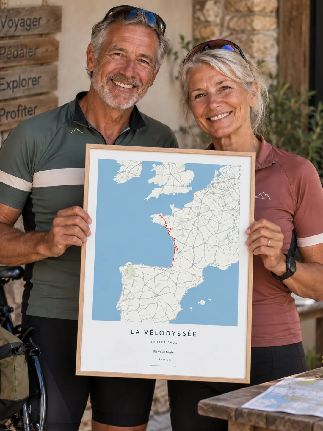
At the 30 km mark
Sunday, twenty to ten. You're on the kerb at the 30 km mark holding a cardboard sign whose glue hasn't quite dried. Three minutes ago you spotted the one race number that matters, then lost it behind a pack of runners, and by the time it swims back into view it's already ten metres away. A hand goes up. You shout a name, and it's too late.
The rest of the day comes back in a handful of pictures: the finish line, the foil blanket, the quick step to one side so nobody sees you cry. And that evening, a single number that everyone repeats, because it's the only one anybody keeps: the time. People talk about it for a week. Then the next week arrives, with its long run, and nobody mentions it again.
What's left of a race, three weeks on
A medal, a race number pinned up somewhere, an activity that slips one place further down the app every Sunday. That's about it, and it isn't much for months of dawn alarms. What the runner really lived was a line: it leaves the square, crosses town, climbs to the bridge, vanishes into the woods. They know it by heart in their legs. They have never seen it whole.
It's also the one thing you can give without getting it wrong: not one more piece of sports kit, but their own line, laid on a map with the numbers that tell its story. Something to catch their eye each morning as they cross the hall, and to make visitors ask: where was that?
The marathon, drawn on the map
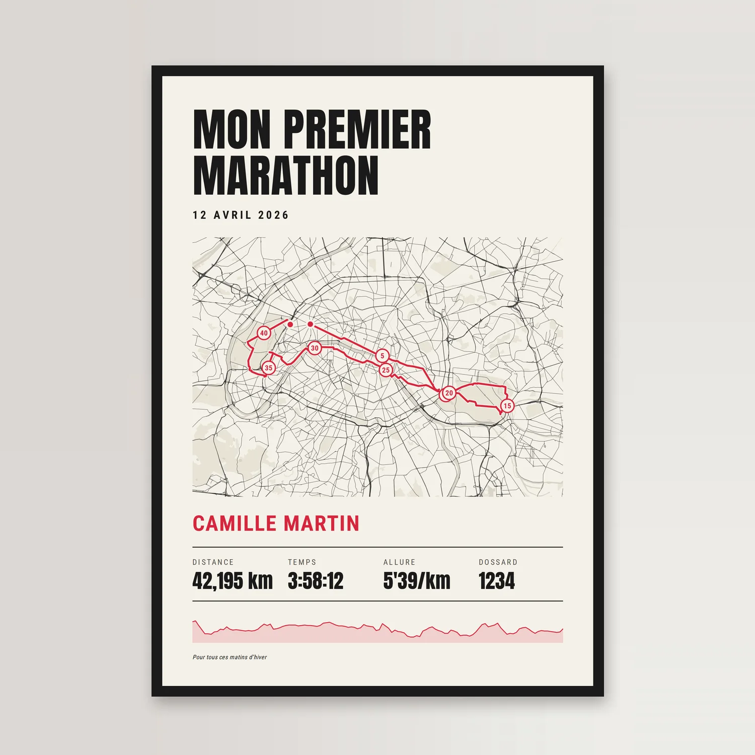
That's what the marathon poster does: the name of the race in big letters, the date, then the route on the map with a marker every 5 km, and underneath the runner's name, their time, pace, race number and the profile of the course. The route comes from the GPX file on their watch, or from their Strava account. Nine styles, from cream paper to a night map with golden streets.
One detail that spares you an awkward moment: the distance printed isn't the one on the watch but the official distance of the event. A GPS almost always measures a marathon a little longer than 42.195 km, because of corners taken wide and a signal bouncing between buildings, and nobody wants to read, across their achievement, a distance they didn't run. Pace is worked out from the event distance and the time you type in. For any other race length, choose “Other” and the measured length of the route is what gets printed.
On a bike, the climbing tells the story
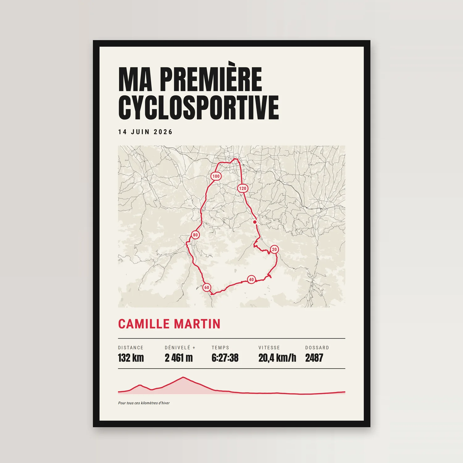
The sportive has a poster of its own, built like the marathon one but around what a cyclist talks about: distance, elevation gain, time, average speed, race number, and the profile that shows the climbs. For a mountain pass you've finally conquered, it's that profile, the relief you know in your thighs, that makes the poster, far more than the line on the map.
Same care over distance: if the event advertises 130 km and the computer logged 128, you type the official distance and it takes priority. Average speed is worked out on elapsed time, stops at feed stations included, so it comes out a little lower than the bike computer's, which usually strips the stops out. Elevation gain is whatever the file says: two devices won't measure the same, depending on whether they carry a barometer or only GPS.
For Sunday rides, the gradient in colour
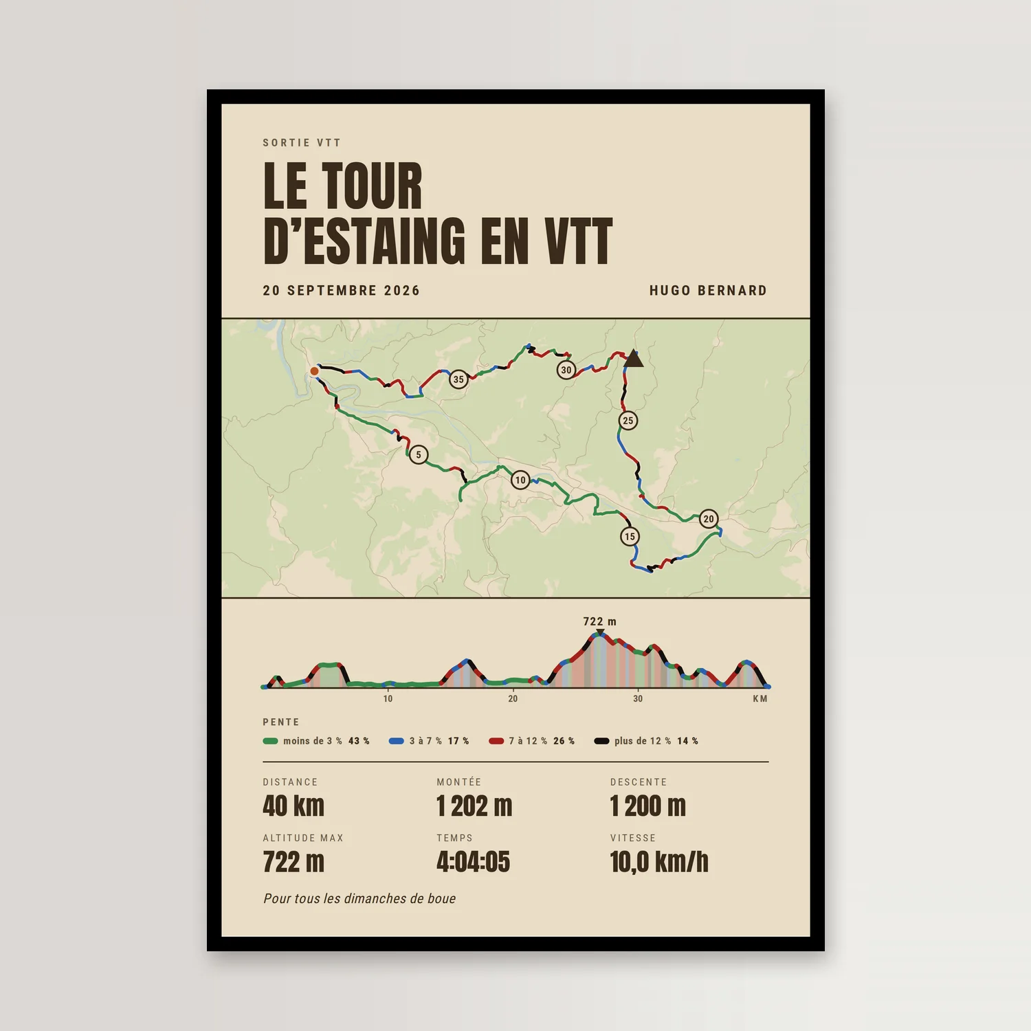
Not every mountain biker has a race number, and the topo-style poster is for them: the route of the ride on the map, coloured by gradient, with the elevation profile in the same colours. Green under 3%, blue from 3 to 7%, red from 7 to 12%, black above 12%. Black doesn't tell you the direction: a 15% descent and a 15% climb are both black.
It isn't a trail grading, which only someone who knows the trail can give: the colour is an average gradient over a stretch of about 250 metres on a 40 km ride, and a short kick or a technical section gets smoothed out. You can read the climbing, the descent, the highest point, the distance, and the time if you want to write it in; the figures come from the file, nothing is made up. Six styles, from kraft paper to fir green.
Getting the route without giving the game away
This is the one real difficulty with the gift: the poster is made from the GPX file of the ride, and only that file knows where they went. Without a route, the sample route is what would be printed. Ask without pressing: “Can you send me your route? I'd love to see where you went.” On Strava's website, on a computer, it's the activity menu and then “Export GPX”; many watches and apps can export one too.
The rest can be found without them: their name, official time and race number are in the results the organiser publishes. And their privacy holds: the file is read in your browser and never sent to our servers, and only the simplified route, the elevation profile and the figures travel with the order.
And if it isn't a race
A multi-day hike, a mountain pass, a cycling trip: the route on its own, with a title and a dedication, exists too, in nine styles. It comes from a GPX file, a Strava account or our library of well-known routes, which helps when you don't have the file; for library routes, only the distance is written. Distance, elevation and duration are worked out from the route, and you can correct them before ordering.
How long before the date
The workshop prints within two days, and then there's the journey. Give or take a few days, allow roughly seven if it's going to France and closer to ten for the rest of the EU. For a date that won't wait, a runner's birthday or the Sunday of their next race, the print-ready file is sent the same day, with all five sizes, ready to take to a local print shop.
Frequently asked questions
What gift should I give a marathon runner after their race?
The race itself: a poster that draws their route on a map, with the name of the event, the date, their time, pace, race number and the profile of the course. The route comes from the GPX file on their watch or their Strava account. You put it together online, and the preview follows every keystroke.
Why isn’t the printed distance the one on my watch?
A GPS almost always measures a marathon a little longer than 42.195 km, because of corners taken wide and a signal that bounces around. The poster prints the distance of the event, and the pace is worked out from it. For any other distance, choose “Other”: the measured length of the route is then what gets printed.
How can I give one if I’m not the runner or the cyclist?
You need their route: ask for the GPX file of their race, which can be exported from Strava's website on a computer or from the watch's app. Their name, time and race number are in the organiser's results. Without a route, the sample route is what would be printed.
What do the colours of the route on the mountain bike poster mean?
The colour is the average gradient of each stretch: green under 3%, blue from 3 to 7%, red from 7 to 12%, black above. It tells you how steep, not which direction, and it isn't a trail grading: a short kick or a technical section gets smoothed out. The elevation profile uses the same colours.
Which size should I choose for a race poster?
A4 and 30 × 40 cm are available framed, in black, white or natural wood, with an acrylic glass front; those are the sizes for a hallway or a desk. The 40 × 60, 50 × 70 and 70 × 100 cm ship rolled, for you to frame at home, and give the race real presence on a wall.
What do you do with my GPX file or my Strava account?
The GPX file is read in your browser and never sent to our servers. With Strava, we read your activities and the route of the one you choose, then hand the authorisation back as soon as the route is imported. Only the simplified route, the elevation profile and the figures travel with the order.